

The South African Weather Service (SAWS) has warned that the Western Cape and Northern Cape provinces will experience very cold, wet and windy conditions on Thursday.
“A high pressure system will be ridging behind a cold front on Thursday and is expected to affect the south-eastern regions of Namakwa, as well as over the Cape Winelands, Central Karoo and Little Karoo municipalities of the Western Cape on Thursday, resulting in cold to very cold, wet and windy conditions,” SAWS said on Wednesday.
The weather service has advised the public to take the necessary precautions to ensure the safety and health of their animals during very cold, wet and windy days.
The Western Cape can also expect damaging winds from Thursday until Sunday.
“A high pressure will be ridging behind a cold front on Thursday, affecting the Western Cape coastline until Friday. This will result in south-westerly waves of 4.0m to 6.0m, as well as wave periods of 10-13s between Saldanha Bay and Cape Agulhas on Thursday morning, spreading to Plettenberg Bay and Alexander Bay in the afternoon, subsiding from Friday morning.
“Windy conditions (40-60km/h) can also be expected along the southwestern and southern coastlines on Thursday,” the weather service said.
KwaZulu-Natal will also experience damaging winds on the east coast from Thursday until Friday.
“A passage of a cold front results in strong southerly to south-westerly winds along the coast on Friday, with average speed of 25 - 35KT gusting 35 - 40KT from tomorrow evening between Port Edward and Mtunzini spreading to Kosi Bay by Friday.”
These weather conditions will result in difficulty in navigation to vessels at sea, with small vessels at risk of taking on water and capsizing within a locality.
Disruption to beachfront activities can also be expected.
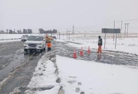
Meanwhile, the Eastern Cape province has been warned of disruptive snow on Thursday.
“Light snow, with surface temperatures below freezing, will follow the passage of a cold front. Although snow accumulation will be minimal, icing is expected on the road surfaces, due to low minimum temperatures on the high ground. Light snow and icy roads will result in traffic disruptions at night,” SAWS said.
Damaging winds will also affect the east coast of the Eastern Cape from Thursday until Friday.
“Strong to gale force W/SW winds are expected as a cold front passes through the province. These strong winds are expected to increase the sea state to about 4.5 to 6.5m from the afternoon. Due to these waves persisting for more than a 24 hour period, wave impacts may be possible,” SAWS said.
The impact will be localised disruptions to harbours/ports and beach activities, difficulty in navigation, small vessels at risk of taking on water and capsizing within a locality and danger to life. -SAnews.gov.za