

The South African Weather Service (SAWS) has confirmed that Tropical Cyclone Gezani, currently located in the Mozambique Channel, poses no direct threat to South Africa.
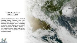
“Latest satellite imagery shows Tropical Cyclone Gezani situated over the Mozambique Channel. The system remains well-defined, with organised convective cloud bands concentrated around its centre. In South Africa, cloudy and cool conditions are observed in the east, with active isolated to scattered thundershowers,” SAWS said on Friday.
Gezani developed over the south-west Indian Ocean to the east of Madagascar and made landfall over Madagascar as a tropical cyclone on Tuesday afternoon.
On Thursday, SAWS reported that Gezani was moving west-southwest and strengthening.
“Under favourable conditions, Gezani is expected to intensify steadily over the next 36 hours and could reach intense tropical cyclone stage late on Friday (13 February 2026) evening near the Mozambique coast. The intensity forecast is then uncertain from Saturday onwards.
“The scenario of a Mozambique landfall remains uncertain and varies among forecast models, but cannot be ruled out,” SAWS said.
Current guidance suggests a very close approach to the Mozambican coast, with the possibility of a partial and temporary landfall.
“This could result in accumulated rainfall amounts of 80 – 100 mm in less than 24 hours near the coast and locally 200 mm at the point of closest approach to the system.
“Wave heights are expected to increase significantly from Friday noon, exceeding 4,0 m and temporarily reaching 7,0 – 10,0 m between Friday night and Saturday morning,” the weather service said.
SAWS has advised vessels operating in or transiting through the south-west Indian Ocean and the Mozambique Channel, as well as offshore marine operations to exercise caution, as rough seas, strong winds, and hazardous marine conditions are expected in the vicinity of the storm. - SAnews.gov.za