

The South African Weather Service has warned the public about the expected impact of an intense cold front set to affect the western parts of the country from Sunday to Tuesday.
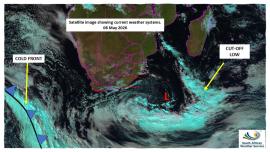
“Following close on the heels of a prolonged period of adverse weather conditions associated with a cut-off low weather system, a strong cold front is expected to make landfall over the Western Cape on Sunday afternoon before progressing eastwards along the southern parts of the country,” SAWS advised.
This weather system is expected to result in widespread disruptive rainfall, strong to gale-force winds, very rough seas, and significantly colder temperatures over the western interior and coastal regions.
Disruptive rain is expected to develop over the western parts of the Western Cape from Sunday evening into Tuesday.
Current indications suggest a low likelihood of severe flooding, particularly over the City of Cape Town, Cape Winelands and Overberg.
“Rainfall accumulations between 100 and 200 mm are possible in some areas, which may result in significant impacts upon infrastructure, transport routes and vulnerable communities.
“In addition, very cold and windy conditions are expected across the western interior of South Africa, with wind speeds ranging between 50 and 70 km/h. Strong to gale-force winds are also expected along the west and south coast from Sunday afternoon, persisting until at least Tuesday night,” SAWS said.
Moreover, there is a high risk of the development of very rough and choppy sea conditions, accompanied by destructive waves, which may pose a danger to navigation at sea and coastal activities.
The following weather-related impacts are anticipated as the cold front progresses over the country between Sunday and Tuesday:
- Orange level 8 warning for disruptive rainfall leading to flooding of roads, bridges and formal and informal settlements, mudslides and danger to life due to fast-flowing rivers is expected over the mountainous regions of the Drakenstein, Stellenbosch, the western parts of the Theewaterskloof, Breede Valley and Witzenberg local municipalities of the Western Cape from Sunday to Tuesday (10 –12 May 2026).
- Orange level 6 warning for disruptive rainfall leading to flooding of roads, low-lying bridges, and formal as well as informal settlements is expected over the West Coast, Cape Winelands, City of Cape Town, and western parts of the Overberg Districts of the Western Cape from Sunday to Tuesday (10 – 12 May 2026).
- Orange level 6 warning for damaging winds and waves leading to danger to navigation at sea and damage to coastal infrastructure is expected along the coast between Lambert's Bay and Plettenberg Bay (Western Cape) from Sunday to Tuesday (10 – 12 May 2026).
- Orange level 5 warning for damaging interior winds leading to damage of formal and informal settlements, power interruptions and closure of some routes due to falling trees is expected over parts of the Cape Winelands and western parts of the Central Karoo Districts of the Western Cape from Sunday to Tuesday (10 – 12 May 2026).
- A yellow level 4 warning for damaging winds and waves leading to danger to navigation at sea is expected along the coast between Alexander Bay to Lambert's Bay (Western Cape) from Sunday to Tuesday (10 – 12 May 2026).
- A yellow level 2 warning for damaging winds leading to localised damage of informal settlements, falling trees and localised problems for high-sided vehicles on prone routes is expected over parts of the West Coast, City of Cape Town, Overberg and Central Karoo Districts as well as the Kannaland Municipality of the Western Cape, including the southern Namakwa District of the Northern Cape from Sunday to Tuesday (10 – 12 May 2026).
- A yellow level 2 warning for disruptive snowfall leading to loss of vulnerable livestock, disruption of traffic due to icy roads and possible closure of mountain passes is expected over the Karoo Hoogland municipality of the Northern Cape and in places over the Cape Winelands District of the Western Cape from Sunday to Tuesday (10 – 12 May 2026).
The public is strongly advised to:
- Monitor official weather updates and warnings issued by the South African Weather Service.
- Avoid unnecessary travel during periods of heavy rain and flooding.
- Never attempt to cross flooded roads, bridges, or swollen rivers.
- Secure loose outdoor objects that may be displaced by strong winds.
- Exercise extreme caution along coastal areas and avoid fishing or recreational activities at sea during the warning period.
- Provide adequate shelter, warmth, and protection for livestock and pets.
- Prepare emergency kits, including flashlights, batteries, warm clothing, blankets, and essential supplies.
- Community leaders and disaster management authorities are encouraged to remain on high alert and activate contingency plans where necessary.
The public is also advised to remain cautious of unauthorised or unverified information sources and refrain from distributing such information further.
For regular updates, visit http://www.weathersa.co.za/ or follow SAWS’ official media channels. -SAnews.gov.za