

The Nelson Mandela Bay Municipality Disaster Management Centre has urged residents, motorists, and pedestrians to exercise extreme caution as heavy rainfall continues to cause widespread flooding and hazardous conditions across various parts of the metro.
In a statement on Thursday, the municipality reported that multiple roads have been affected, with law enforcement and traffic officers deployed across affected areas to monitor the situation, manage traffic flow, and assist residents where required.
Several incidents and road closures have been confirmed, including, among others:
• A motor vehicle accident was reported at 4:43pm on 6 May 2026, on the M4 Albany Road. No injuries were recorded.
• The Third Avenue Dip remains closed due to flooding and unsafe driving conditions.
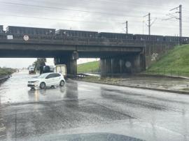
• The N2 freeway between John Tallant Road and the M4 East and West interchange remains closed as a result of flooding. Traffic is currently being diverted via Old Grahamstown Road, with traffic officers assisting on the alternative route to alleviate congestion.
• Several roads across the metro remain flooded, with traffic and law enforcement officers currently assessing affected areas and monitoring conditions.
Motorists have been advised to avoid flooded roads, bridges and low-lying areas; reduce speed and maintain safe following distances; use alternative routes where possible and adhere to all instructions issued by traffic officers and emergency personnel.
Authorities have also cautioned against unnecessary travel during periods of heavy rainfall.
“Pedestrians are advised to avoid crossing flooded roads, streams and stormwater channels; exercise caution near bridges, drains and waterlogged areas; and keep children away from fast-flowing water and flooded zones,” the municipality said.
The municipality said emergency and disaster response teams remain on high alert as they continue to monitor weather conditions and infrastructure impacts.
Residents have been encouraged to continue monitoring official Nelson Mandela Bay Municipality communication platforms for verified updates, emergency notices and safety information.
Cyler bridge overflowing
Meanwhile, residents in Kariega must take caution as the Cyler Bridge is currently overflowing due to heavy rains.
Motorists have been advised to use these alternative routes:
Algoa Road (R368), which connects to the R75 and passes through Despatch. From Despatch towards Kariega: traffic is diverted off the R75 at the Botha Street off-ramp, directed to proceed via Algoa Road (R368) into Kariega, and can rejoin the R75 at the Union Street on-ramp. From Kariega towards KwaNobuhle/Rocklands: use Melbrookes Avenue or Matanzima Road to access Rocklands Road.
“Do not underestimate the depth of water,” added the municipality – SAnews.gov.za